 The Belize River is the Vena Cava, Belize’s main vein. Historically
and hydrologically it is the country’s most important water way. And it
is also the biggest, fed by the greatest number of tributaries. It also has
the largest network of streams- which is why tonight it is the final staging
ground for the rush of flood waters rolling downstream from Cayo. All eyes are
on the Belize River and today we found out why.
Keith Swift Reporting,
This evening Belize’s biggest inland waterway, the mighty Belize River
was roaring beneath the Haulover Bridge forming a furious cycle of constantly
churning eddies. And while the sight and volumes are a force to behold, three
miles up the road it is a sight to fear as the swollen river’s currents
and girth are lapping up and eroding the banks – and slowly eating away
at the Northern Highway.
Rudolph Williams, Hydrologist
“I have always been concerned about that and I mentioned this more
than once during this event that I have seen the erosion of the buffer between
the road and the river and these things have a way of occurring under the banks
and then they give us some surprises later on that we weren’t expecting.
So like I said it has happened before on this highway just recently and it can  happen again. So I would ask drivers to be cautious and be careful when travelling
on the highway. happen again. So I would ask drivers to be cautious and be careful when travelling
on the highway.
The advice everybody is to listen to the reports, do not go into water
that you feel is unsafe for you because a small amount of water on a asphalt
road can easily cause a vehicle to slide.”
Williams says this is the full force of flood waters which are causing mass
inundation – even in the met office’s backyard.
Rudolph Williams,
“The peak of the wave is pushing the water down and at this time again
we have the occurrence of a fallen tide and so the water has little obstruction
getting out of the Belize River mouth.
The peak of the waves are approaching Boom at this time and so we continue
to expect that that wave will move downstream towards the Ladyville, Lords Bank,
Belize International Airport Area and on to Belize City under the Haulover Bridge. 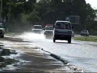 We expect that that will be probably sometime tomorrow or late tomorrow evening.” We expect that that will be probably sometime tomorrow or late tomorrow evening.”
Keith Swift,
So what can people in those areas expect?
Rudolph Williams,
“Okay they can expect that water levels will continue to rise. On
the Northern Highway there is the possibility for it to go over but yet I still
have not seen any reason to tell me yes it is going to go over. We have recently
installed a gauge near the Williamson sewing factory where we are monitoring
it and every time we pass there we have been monitoring it and making sure that
we are top of it if it is going to go over the road. What we have found though
is that near Manatee Lookout area along with the occurrence of the high tide
the water has been trickling over that area and we can expect that this will
reoccur as it occurred last night and this morning around the time of the high
tide.”
Williams warns that the water won’t be going anywhere quickly.
Rudolph Williams,
“The rains that came for us, there was direct rainfall into the depression
or the wetlands and those areas, some of them are only connected to the river
during the flood waters. So as flood waters are leaving some of these areas,
the water remains in these depressions or wetland areas and it takes a slower
release from these areas. So you will not see these going away for a while and
every little depression that is there, some of them are only partially connected
to the river systems and have become full and are releasing very very slow.”
There is a high tide at 9:11 tonight and as Williams noted, the possibility
for flooding is greatest when the tide is high. And as regards the stretch of
road between Manatee Lookout and the airport junction, a Ministry of Works crew
started working on a nearby culvert this evening to try and ease flooding.
And stay tuned for more about the flooding and how it’s affecting
the Belize District; as we’ll take you out to Maypen where there’s
been a small outbreak of water – borne illnesses. |