 For the last 4 days, thunderstorms and heavy rains have dominated the weather all across Belize. The heavy conditions started on Saturday, and were as a direct result of a tropical weather disturbance that began affecting Belize and other Central American nations.
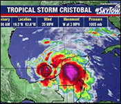
This bad weather actually pre-empted the start of this year's hurricane season, and now, it has developed into one of the first-named tropical storms of the season.
It is now known as Tropical Storm Cristobal, and at this time, it is meandering in the Bay of Campeche, where it will stay for a few more days. Additional heavy rainfall is expected to occur in parts of southern Mexico, Guatemala, El Salvador, Belize, and Honduras. That means that those heavy downpours you've been experiencing all over the country may continue well into this coming weekend.
This afternoon, we got a chance to speak briefly with the Deputy Chief Meteorologist about Tropical Storm Cristobal:
Ronald Gordon - Deputy Chief Meteorologist
 "The latest on that system is that it has emerged into the Bay of Campeche. It was officially declared as Tropical Depression #3 yesterday. And now, it has been upgraded to Tropical Storm Cristobal."
"Currently, Tropical Storm Cristobal is a weak tropical storm with winds of 40 miles per hour. The system is expected to meander in that general area for the next few days. And given its current position, it will continue to draw moisture from the Pacific into our area, resulting in downpours of showers and thunderstorms, especially at night time, for the next few days."
"It will continue to produce a lot of rainfall across the country. However, going into the weekend, the official forecast is suggesting that the system will start to move northward away from the Bay of Campeche. And as it does so, a drier south-easterly airflow will develop going into the weekend. So, we're looking at around Saturday/Sunday for improving conditions."
"Heaviest Activity is forecasted for the northern parts of the country, the Orange Walk, Corozal, and Belize Districts. Whereas the south could get some rainfall as well, but it should be lighter than up in those areas I described."
"Flooding is certainly a concern, and for that reason, we have maintained a flood alert on our website, and we also broadcast that on our forecast on the radio that is updated 6 hours. Especially areas that have been affected already, that is already saturated with water, those could get flooding, but we're also alerting residents along rivers and streams, and those in low-lying areas, to be on the lookout for flooding."
"On the high side, I can report that Belmopan and other portions of the west and northwest parts of the country received up to 10 inches of rainfall between Saturday and Sunday. Fortunately for us, the rainfall that fell today and yesterday affected areas. So, the Belize City area got rainfall yesterday morning, and again this morning, amounting to about 5 to 6 inches of rainfall."
A report from the National Hydrological Service says that the Blue Creek Sub-catchment of the Rio Hondo is flooded. Flood levels have exceeded the historical levels recorded for Hurricane Mitch. The New River continues to rise slowly but remains below the banks. On the Macal river, reservoir levels remain below spillways at the Chalilo, Mollejon, and Vaca facilities. The Mopan River in Benque Viejo Town has exceeded its banks and continues to rise. The Sibun River near Freetown Sibun is flooded and has exceeded its banks. On the Coastal Road, the bridge near La Democracia was impassable due to floodwaters.
The National Met Service is imploring Belizeans to keep a close watch on this hurricane season, which started yesterday. Once again, regional forecasters believe this season will be more active than normal, and that as many as 19 named storms could develop between now and November 30th.
Here's the Deputy Met Officer on that topic:
Ronald Gordon - Deputy Chief Meteorologist
"The consensus among most of the agencies that produce seasonal hurricane outlooks is for above normal. The one that we look at a lot is the National Oceanographic Atmospheric Administration from the US, and they're going for 13-19 named storms for this season. An average season is 12. So, they're going for 13-19. Of those, they forecast 6-10 to become hurricanes, and 3-6 could be major hurricanes, category 3 and higher."
|