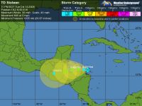
NEMO has issues a tropical storm watch for Belize City down to southern
Belize at its border with Guatemala. This as tropical depression number 16 slowly
churns towards the coast of the Nicaragua-Honduras border. That puts it right
in Belize’s back yard. The latest advisory from the National Hurricane
Center has it moving northwest a 6 miles per hour with wind speeds of 30 miles
per hour. The really bad news is that if it stays on its current track, it could
be a tropical storm by tomorrow. For those in the south, that could mean evacuations
within the next two days. We discussed its development with Chief Meteorologist
Ramon Frutos.
Keith Swift Reporting,
As these projected paths indicate – most computer models put Tropical
Depression 16 on a beeline to Belize’s southern coast.
Ramon Frutos, Chief Meteorologist
“The general motion when you combine all the model runs and tracks
is towards the west and that would put it over southern Belize. So it is something
that we need to be concerned about because as we all know with these systems
if it becomes a tropical storm, the heaviest convectionary activity and the
strongest winds will be to the north of the city so it is something we’ll
be watching very closely.”
Chief Meteorologist Ramon Frutos says the biggest concern is rain.
Keith Swift,
Who should be concerned?
Ramon Frutos,
“Residents who southern and central Belize especially those in the
Stann Creek and Toledo Districts should be very much concerned because of the  amount of rainfall this thing will bring in over the area. We can expect rainfall
in excess of 15 inches and this amount of rainfall with the amount we’ve
been getting over the past couple of days could be very dangerous because it
could result in rapid runoff and flash flood conditions in the hilly terrain
of the Stann Creek, Toledo, and even Cayo District. So it is something that
we need to watch. How early can this begin to materialize or occur? It could
be as early as tonight or during the day tomorrow or into Thursday. The heaviest
rainfall activity of this system continues to move along its projected path
towards the west will be during the period on Wednesday afternoon and Thursday
night so this is the period when we’ll get most of the rainfall.”
amount of rainfall this thing will bring in over the area. We can expect rainfall
in excess of 15 inches and this amount of rainfall with the amount we’ve
been getting over the past couple of days could be very dangerous because it
could result in rapid runoff and flash flood conditions in the hilly terrain
of the Stann Creek, Toledo, and even Cayo District. So it is something that
we need to watch. How early can this begin to materialize or occur? It could
be as early as tonight or during the day tomorrow or into Thursday. The heaviest
rainfall activity of this system continues to move along its projected path
towards the west will be during the period on Wednesday afternoon and Thursday
night so this is the period when we’ll get most of the rainfall.”
And that’s why Frutos says those living in the central and southern Belize
should:
Ramon Frutos,
“Continue to monitor this very closely and begin to make preparation
in the event that they need to evacuate suddenly and evacuation could occur
in the middle of the night so we should be prepared. They should at least know,
have a plan of where they will go if they need to evacuate first of all, if
they are going to the higher elevation in your community, the higher points
into a shelter, or a community center or into the church or into the school,
have a plan where you’re going first of all. Notify your family about
your plans and also have some food just in case you have to stay in there for
a short while, probably for a day or so.”
A NEMO official says the Prime Minister has been briefed and NEMO Subcommittees
have been activated. The Coast Guard has dispatched personnel to the southern
cayes, including the Turneffe Caye Island Range to evacuate residents. Residents
in areas prone to flooding have been told to move to higher ground and place
their crafts in safe harbour. NEMO will continue monitoring the progress of
the storm. We note it is still a tropical dpression and is slowly moving west
north west at 6 miles per hour with wind speed of 30 miles per hour.
We should note that though there is a huge difference in size, Tropical
Depression 16 is following more or less the same path that Hurricane Mitch took
in 1998. The track also resembles Hurricane Iris in 2001. Both of those were
October storms. Click here
for the most updated forecast.