Last night we showed you a legal Xate Camp in the heart of the Chiquibul
National Park. That’s part of a tour we did with the Friends of Conservation
and Development of some of the affected areas and hotspots within that over
two hundred thousand acre area. It is a special place and in part one of our
story on Chiquibul – we’ll show you some of it.
Jules Vasquez Reporting,
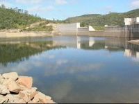
Here at Chalillo where the wide span, 420 feet of the 150 foot high containment
wall holds in and harnesses the upper branch of the Macal, one can truly appreciate
the sharp juxtaposition of what’s probably Belize's greatest civil engineering
feat buttressed against nature's finest creation, the broad breathtaking landscape
of Chiquibul. Jarring but compelling, as the coppery tones of the boulders blasted
to clear the land for the dam - form a neat contrast against the still waters 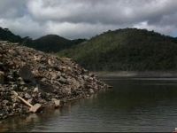 of the reservoir and the lush green hills on the horizon.
Taking us inside Chiquibul are two Friends of Conservation and Development
rangers and the organization’s director Rafael Manzanero and the Scarlet
Macaw project field biologist Lenny Gentle. The reservoir covers 2,347 acres,
9.5 square kilometres of an area whose topography has been radically re-shaped
by Chalillo. To understand this vast body of water we're on, it is the upper
Macal, but engorged by Chalillo which inundated eight square kilometers of forest
almost two thousand acres of forest to create the dam reservoir.
Looking at it from the other side, here at the head, the depth is well over
100 feet, depths unheard of in a river. But it is still a river albeit widened
and deepened by the reservoir. It cuts a wide swathe through the Chiquibul that
we see crowding the horizon beyond the boat's prow. To understand how deeper
and wider the Upper Macal and its tributaries are, you'd have to see these drowned
patches of forest, areas that used be dry land before the creation of the reservoir
inundated the area. The pallid color of the branches set against the lush,
thriving green of the surroundings make for a jarring juxtaposition - and now 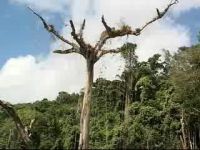 only the their bare and barren branches seem to reach up helplessly to the skies
for deliverance, as the river that so long fed them, now smothers their roots
somewhere beneath the depths.
only the their bare and barren branches seem to reach up helplessly to the skies
for deliverance, as the river that so long fed them, now smothers their roots
somewhere beneath the depths.
But that same reservoir widened river carries us smoothly and snag free through
to the interior of the Chiquibul National Park, areas that would have been largely
inaccessible before.
Today the rangers are in a motorboat, but usually they paddle up this wide
waterway to conduct their patrols. Cormorants or what most people call a sheg
lead the way. But it's not the common sheg, we're looking for today, it's the
scarlet Macaw, the prize of Chiquibul – there’s an estimated population
of about 200. Lenny Gentle explains.
Larry Gentle, Scarlet Macaw Project Field Biologist
“This is where we are on the Macal River. So we are heading towards
the Rascapulo Branch which is the main territory for the Macaw. The Macaws are
not only in the reservoir, they are also outside living all about the forest
but there is a high concentration of nests around this area.”
And he's right, within minutes after we set off, we sight a flock of scarlet
Macaws in the wild, a special moment, as the brilliant colours of their wings
lead a dance above the forest canopy, and they disappear into the cover, diving
into green. The macaws live nearby in Quamwood trees on the river bank.
They depend on the soft wood and the forces of nature to make a home for them
Larry Gentle,
“The macaws don’t know to make cavities and so they depend on
nature to make cavities for them.”
Like this one - where you can saw the Macaw's colourful beak peering out. And
those high trees where they make their nests added to the clamour they create
make them an easy target for poachers - which is an increasing problem for FCD.
Larry Gentle,
“What we’re founding since over the last two years we have a 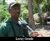 lot of the Guatemalan xatero poachers who basically cross the border and they
come almost 15 miles to collect their chicks and also we’ve been finding
some places where they actually cut the trees down with chainsaws, cut them
down with machetes or axes to get to the chicks if they cannot climb.”
lot of the Guatemalan xatero poachers who basically cross the border and they
come almost 15 miles to collect their chicks and also we’ve been finding
some places where they actually cut the trees down with chainsaws, cut them
down with machetes or axes to get to the chicks if they cannot climb.”
There are also other problems that Guatemalan encroachers create like these
burnt trees. This tree used to be the nesting area for a pair of macaws, but
now it's as burnt and destitute as a solitary matchstick. This quamwood tree
shows the trail of climbing spurs, meaning someone has clambered up to capture
the macaws. It's a sore sight and an unbelievable activity for an endangered
bird in a national park, but it’s real and it is economics.
Larry Gentle,
“For me it is definitely frustrating after being out here for the
last five years. I’ve seen a lot of damage, you know the flooding of the
dam and now we have poaching. This is unprecedented poaching. Basically we have
lost about ten macaw nests cavities so far. Ten, and now we have reports that
these things are being sold in Guatemala for about 3,000 quetzals.”
And while that's a sore sight, those are in the minority those who traverse
the Chiquibul, be they Xateros or wide eyed sightseer like me, will inevitably
encounter natural wonders like this, natural, year round spring, a juvenile
tapir, feasting on fresh grass. He seemed shy but not too disturbed, as he made 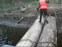 a slight retreat - but we still found him through the thicket maybe even posing
for us. His business finished, he rushed along. Later on, in another area, we
spotted a slightly larger juvenile gamely navigating this tangle of limbs.
a slight retreat - but we still found him through the thicket maybe even posing
for us. His business finished, he rushed along. Later on, in another area, we
spotted a slightly larger juvenile gamely navigating this tangle of limbs.
But the Tapir's have company, and we don’t mean us. These rafts
are what the Xateros use to cross the river after coming from the west through
dense difficult forests.
Larry Gentle,
“At first they were not around here because we actually are about
15 miles from the border but now they have penetrated our forest so far, it
is unbelievable to know how far they are now extracting xate. This is considered
like a core conservation area.”
Core conservation in the heart of the Maya Mountain range, but fair grounds
for Xateros. In just a few minutes we come across half a dozen rafts all on
the west side of the river, parked there and ready to take the Xateros east
where the plant is plentiful. Eventually it’s too much, and the
FCD rangers take the decision to disable the rafts. It's fairly simple
and just requires detaching the cross member or severing the tying wire with
a machete. The rafts are not much, two logs nailed or tied together but
the Guatemalans who use them just need something to flat them across the river
- and some judging from the size of this monster could float a family across.
It's just one sign of a battle FCD continues to fight even if only symbolically.
Rafael Manzanero, Director - Friends of Conservation and Development
“The cutting of the raft or the tine material used for the rafts,
at least it means that people can get the feeling that there is a presence,
that people are around that area. But it has to be much more consistent.”
Tune in tomorrow for part two when we’ll show you live Tapirs
in the wild on the banks of the Macal.