 Faithful viewers will recall that in 2007 we did a number of features with Dr. Jaime Awe called Glimpses Into the Past - where he take us - via digital images - to maya sites all across Belize. Tonight, he's back but the information he's releasing is brand new. It's about a new high tech mapping of the Caracol area and what it shows has surprised Archaeologists. Here's more:....
Jules Vasquez, Reporting
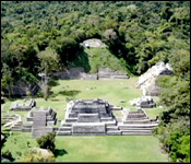
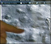
This is the Caracol we all know - the spectacular Kanaa, its hulking features rising magisterially out of the Chiquibul like a behemoth bestride the expanse of forest. But this is the Kanaa as seen by a new imaging technology called Lidar - it may look like nothing much as the distinctive Temple - one of the largest buildings in all Belize - is reduced to a mere blip on the screen - but look beyond and you'll see a lot more
Dr. Jaime Awe
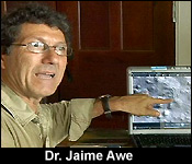 "If you look carefully you can see Kanaa, you can see all the other temples. That is a reservoir, that is another reservoir, there, another little reservoir and do you see all these lines going down? There is one going like that there and another one going like that. Those are ancient causeways, those are roads that the Maya built. We have been seeing roads that we even know existed!"
And the image also exposes a complex, highly organized city state
Dr. Jaime Awe
"If you now start to look how densely occupied this city was. At the top of every hill here you see buildings. And then all around the buildings it's like every family has their own agricultural terraces all the way down the hills and all the roadways linking the center of Caracol with other parts of the 'ancient' polity of Caracol."
The LIDAR image also shows a highly agrarian society
Jules Vasquez
"You see all those lines, those ripples."
Dr. Jaime Awe
"All those ripples. The Maya that lived at Caracol had denuded that forest they had constructed these terraces with cut stone walls so that they could farm and do agriculture."
And Awe says it offers a clue to the demise of the Maya:
Dr. Jaime Awe

 "When I see this kind of imagery what it tells me is that the ancient Maya really destroyed a lot more forest than I ever thought of. I think that when we see this image, it's starting to tell us, you know what, maybe the Maya caused their own downfall by doing this kind of clear cutting and intensive agriculture. Eventually they got hit by droughts; you know it would have spelt major problems. They eventually would have abandoned some of these areas."
And if it so illuminates the polity of Caracol, what about all those sites all across Belize?
Dr. Jaime Awe
"We can do this for the entire country or even half of the country. I think that the information that will be revealed by this technology is anybody's guess."
The LIDAR project and Dr. Dianne Chase who led the research will be featured prominently at the upcoming annual archaeology summit to be held from June 30 to July second in San Ignacio.