 Tropical Storm Matthew is located three hundred and eleven miles away from Southern Belize and is expected to make landfall in Belize sometime on Saturday.
Heavy rainfall is expected throughout the next three days. In a telephone interview with Seven News late this evening NEMO's National Coordinator, Noreen Fairweather gave us their latest advisory.
Noreen Fairweather, NEMO's National Coordinator
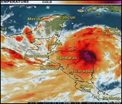
"This evening at 6 pm Tropical Storm Matthew was located near latitude 14.9 degrees north and longitude 84.4 degrees west and that's about 310 miles east southeast of Belize. The storm is currently moving towards the west. The speed has decreased a bit about 15 miles per hour, as you can recall a little earlier it was moving faster about 18 miles per hour. It is now approximately 15 miles per hour. In terms of the wind; winds remain near 50 miles per hour with higher gusts. We do expect that it will weaken during the next 48 hours as it moves over land. The system is expected to become a tropical depression on Saturday. It is anticipated that it will make landfall in Belize on Saturday afternoon or in the evening. We expect a significant amount of rainfall up to about 12 inches is expected thru Saturday, Sunday and Monday, with higher rains in the southern part of the country. So we are looking at significant amount of rain. So we are advising people in that flood prone to move early especially those that need to cross that they know are prone to flooding to move early and move into a safe area. we also have a lot of people in the rural community with livestock and so on in low lying areas, they need to start moving their livestock to higher ground. We have in past events where a lot of livestock trap in flooded areas so the farmers need to start moving their livestock to higher ground. We are advising persons travelling particularly in the south of the country not to travel in the southern cayes at this time. Base on the last advisory the storm has shifted a little bit south. So we are focus in terms of choppy seas and more deteriorating conditions in terms of sea state, we are looking initially at the southern cayes near the Gulf of Honduras and Toledo, and Stann Creek areas, we are advising persons not to travel at the cayes at this time. We have report from the coast guard that seas out there are pretty choppy, raining heavily and so it's not pleasant so people need to be very careful and not travel in those areas at this time. We are still in a preliminary phase and a tropical storm watch is still in effect so we do continue to advise the public to remain vigilant and be prepared for heavy rains which can cause life threatening floods and we are looking at rain over a couple of days, Saturday, Sunday and Monday perhaps even later than that, so we are looking at days of rain. People need to be careful particular in areas along the road that you know are prone to flash floods. In areas like Blue Creek, Jordan you know we have the Kendall crossing, these areas are prone to flash flooding. At night we need to be careful in these areas where we can't see. That is a major concern. We ask the public to please listen to the official release and advisories given by NEMO and the national MET service."
The preliminary phase and a Tropical Storm watch are still in effect for the entire country. NEMO'S adviSES the public to remain vigilant and prepared for heavy rains which can cause life threatening floods.
You can watch channel 7 for regular NEMO bulletins…