 Today, all across the country the red flags went up - as Belize was put under Hurricane Watch.
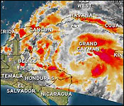
Tonight, we are under a hurricane warning, which means that two Red Flags are now flying - with Tropical Storm Ernesto packing winds of 65 miles per hour and located 415 miles East of Belize's coast or 410 miles east south east of Belize City.
The 6:00 pm update from the National Hurricane Center in Miami reports that Tropical Storm Ernesto is moving west North West at 12 miles per hour - which puts it on a track to make landfall north of Belize by Wednesday.
The worry is that it can strengthen to a hurricane by later tonight and continuing to strengthen throughout the day tomorrow.
Now, this is just a projection, a forecast, but anything and everything can change in the life of a storm.
Twenty minutes ago we spoke vie telephone with the Chief MET Office, Dennis Gonguez to find out what the latest information means for Belize:..
Dennis Gonguez, Chief MET Office
"At 6pm today Tropical Storm Ernesto was near latitude 16.5 north, longitude 82.1 west. That position is about 110 miles east south east of Belize City. Tropical Storm Ernesto had maximum sustain winds of 65 miles per hour heading towards the west North West at 12 miles per hour."
"Our 7 day forecast track takes Tropical Storm Ernesto up near the northern sections of our country and making landfall somewhere around midnight around 3am on Wednesday morning."
Monica Bodden
"At 6pm it showed the storm had winds of 65 miles per hour moving west North West at 12 miles per hour. What does that mean for Belize?"
Dennis Gonguez, Chief MET Office
"That means that we should see some deterioration in the weather some tomorrow morning and by 3pm - 6pm tomorrow we should start experience tropical storm force winds in the outer cayes area and offshore waters."
Monica Bodden
"How soon will it make landfall on the out laying islands and Belize mainlands?"
Dennis Gonguez, Chief MET Office
"Around midnight on Tuesday and then on the mainland around 3am. Presently the tracks takes it somewhere around the border with Mexico, however Belize City is still in that uncertainty area."
Monica Bodden
"Anything else you'd like to add Mr. Gonguez?"
Dennis Gonguez, Chief MET Office
"Tropical Storm Ernesto has the potential to develop further and become a category 1 hurricane before landfall. So it's quite possible that you could see a category 1 hurricane with about 75-80 miles per hour winds just before landfall tomorrow night or early Wednesday morning. So we should pay attention to Tropical Storm Ernesto as it nears the country."
Channel 7 will have regular updates on the storm throughout the night.
But the situation right now is that NEMO'S 6:00 PM ADVISORY stresses that Hurricane Warning Red 2 is in effect for the entire coast of Belize.
NEMO will be opening shelters for those who are evacuating and seeking safety at 2:00 p.m. tomorrow afternoon. That means Public Officers must be ready to report to their respective shelters.
Tomorrow additional public transportation will be made available by the bus operators to assist the public moving inland.
Small Craft should seek safe harbour at the end of today or tomorrow morning at the latest. The Coast Guard has been warning and encouraging people to move inland from the Cayes.
Those persons who are capable of leaving the Cayes on their own are advised to voluntarily evacuate! If you are going to Shelters you should take along food and water.
Areas of greatest concern are: Gales Point and Mullins River, Belize City, Hattieville, Western Paradise, Lord's Bank, Ladyville northwards to Sand Hill and Maskal. Rural areas in Orange Walk and Corozal Districts including: Bomba, Progresso, Copper Bank, Chunox up to Sarteneja.
Later on, we'll have more on the storm for Belize City Residents as the Mayor addresses CEMO's plans - and coming up we'll also have the regular evening weather report.