 Often in the news, we show you interviews with police commanders in which they describe police response to crime in their jurisdiction. It usually involves some sort of increased presence on the ground, most times, in the form of more patrols in crime-ridden areas.
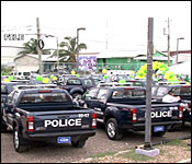
But how effective are they? Well, there is no empirical data readily available to the press, but Southside Commander Chester Williams appears to have put a new spin on business as usual in the battle against crime. He and the other police administrators have carved one of the country's most difficult areas to police into a series of patrol zones. Their police and vehicular resources are strategically placed and carefully managed to make the best use of their new vehicles from the US Embassy. Using what is known as geo-fencing, these vehicles give off GPS positioning, which the Southside commander can track and manage in real time, to ensure that all the crime hotspots in their area are covered.
Today, Williams discussed how it works, and why if you're living on the southside, you might see certain type of marked police vehicles in your area:
ACP Chester Williams - OC, Eastern Division South
"What we basically try to do is to do more hotspot policing. We try to restrict these vehicles to the respective areas so as not to have them stray away. It is something that we believe that will work better for us in 2017. We only just started it since we got the fleet of vehicles. So, we are anticipating that 2017 will be a good year for us."
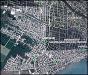
 "If you look at each of the vehicles assigned to South Side, you will see that each vehicle have a designated area. I don't know if you noticed that, but there is a vehicle that is assigned to the Jane Usher Boulevard area. There is one assigned to the Yaba area. We have a Southern Foreshore Patrol. Then, we have the Mayflower Patrol. The Mayflower Patrol is responsible for that area from Cemetery Road, all the way to Belcan Bridge, which includes Banak Street, Mayflower, Sarstoon, Sittee, 'Bak-A-Town' Area. Then, we have the Martin's Patrol. The Martins Patrol is responsible basically for the PIV area. That will be from the Boulevard to Complex Street. From Mahogany to the River. Then we have the Extensions Patrol. The Extensions Patrol is responsible for the area from Cemetery Road to Penn Road, Boulevard, all the way to the back. Then we have the Strike team vehicle, which is one of the new vehicles as well. And the Strike Team vehicle is responsible for the George Street area."
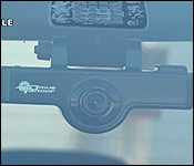
"There is an office that I have established, and that office is the vehicle tracking office. We have a computer in there, and the officer in that office is responsible to monitor the movements of these vehicles, to ensure that they do not leave the area, 1., to ensure that the vehicles are not constantly running because we do not to be out there turning fuel into fumes. So, what the vehicles are to do, they are to patrol for a certain period of time, then, they go and park at a hotspot. And the reason you park at the hotspot to be able to contain whatever crime may come out of that hotspot."
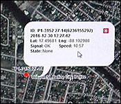
"The geofencing is on the vehicle, and once the vehicle leaves its area of patrol, the system sends an email to me. If the vehicle is going too fast, it sends and email to me. So, I can always call the police in the mobile, and I can tell them, 'You know what, you're going too fast, or you have left your area of responsibility. And, they are not to leave the area of responsibility, unless they are directed to do so by the commander."
"So, basically, we have every area of South Side Belize City covered with vehicular patrols."
Williams told us that this patrol focus on hotspots and strategic routes is something new he's implementing, and the hope is that it will be successful.