 Recently, we've been showing you how the Sugar Industry in the north has been slowly incorporating technology, and modern farming practices to try to improve their productivity and competitiveness.
Well, recently, the Sugar Industry Research and Development Institute has been working on trying to reduce the headaches that the farmers experience when they have to face heavy rains which disrupt the crop season.
They introduced a new system today, and they invited the media out to the Orange Walk District. Daniel Ortiz reports:
Daniel Ortiz reporting
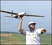
It may look like this gentleman is out in the middle of a cane field having fun with a remote controlled plane. But actually, this is a drone, and he's working.
This drone is special, and its purpose is to help his company, the South African firm, Agri-Sense, conduct aerial surveys of the land in the Corozal and Orange Walk Districts which is mostly covered by sugar cane fields.
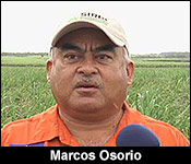 Marcos Osorio - Director, SIRDI
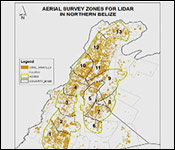
"We are in an area between Guinea Grass and San Lazaro, known as Ridgemond Hill, and here we are about to start an interesting project for the Sugar Industry and the 2 northern districts of Belize. This project is titled land use management and we are about to start doing a Lidar survey, which is using one of the highest technologies, using laser to collect topographic data, which will be done in 900 square kilometers within the sugar belt."
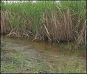
That's a total of a little more than 347 square miles of cane country that the Agri-Sense team will be surveying, and it's actually the first phase of a drainage masterplan. The Sugar Industry Research and Development Institute (SIRDI) wants to help farmers deal with an acute problem that resurfaces every time there is excess rains in the north.
Marcos Osorio
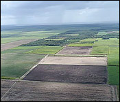
"The northern part of the country is known as general flat plains. Every time we get rains, you'll find water everywhere. So, this particular project aims - or the final result will be the design of a master drainage plan for the northern districts of Belize, particularly for the sugar industry, but it will impact across every sector within the sugar belt."
Excess water in cane fields results in no oxygen to the root system, and having no oxygen, then there is no growth. The issue of water-logging... in the northern part of the country, for the sugar industry, has resulted in more incidence of pest, lower yields and much inefficiency in the sugar industry.
(SIRDI) That point was driven home back in December of 2013, when the Sugar Crop for that year had to be delayed because of the excess rain which flooded the mature cane fields.
File: December 16, 2013
Leocaido Javier Keme, Cane Farmer
 "Obviously, these canes have been under stressed absorbing water from weeks I could say and even though you can see the cane has the height it looks as if it is ready, but if you test it, if will give you maybe 65%-70% of purity."
Marcos Osorio
"It affects the cane field. It affects the land, and generally, it brings about a poor output of sugar to the mill. And it affects everyone within the sugar industry."
That's where this drainage master plan comes in. It will be designed to mitigate the damage to the sugar industry due to flooding.
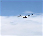
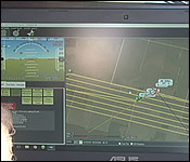
So, what role do the drones in this? Well, they will help Agri-Sense complete the first phase of the master plan. This is the reconnaissance phase and these professionals are experts of technique called stereo photogrammetry. That is the science of making measurements from photographs.
Russell Longhurst - Managing Director, Agri-Sense International
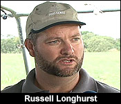 "We have ground controlled points which we've put. That's the ground team that's working in advanced of us. They've put down ground control points throughout the area, which we'll use to tie in the model. Those points are measured to an accuracy of 2 centimeters… Then the drone flies over, takes a picture of the marker. We know the position of the marker. We know the position of the drone, and then we can actually get the accurate elevation and tie all those points together to get a model. Our part in this whole thing is to develop an accurate elevation model, so that the engineers can design a drainage master plan on top of that."
They are in Belize for 30 days to cover about 15 square miles a day with the drones, until they've photographed the entire 347 square miles of territory that they've been contracted to do.
Russell Longhurst
"We'll send the UAV's into the air, one then the next. And we'll be covering an area today, probably about 4,000 hectares of survey."
After that, there are several other phases, that will span months, but the end goal is to actually see this drainage masterplan become a reality.
The SIRDI director believes that this project will see improvements in areas other than agriculture.
Marcos Osorio
"It will bring benefit, not only the sugar industry. It will benefit the road network infrastructure. It will benefit the communities that are prone to flooding. It will benefit tourism, and I think it will bring about major developments for the northern districts because water management is a big issue. It's something that we've not really done anything… So, we estimate, or the vision is that 20 years from today, the whole northern districts should be transformed."
As you heard in the story, this the very first phase of this drainage master plan. There are several steps that must take place before any actual construction takes place.
But, the survey team has been having some difficulties with some landowners in the survey area.
The Director of SIRDI told us that specifically in Ship Yard, the ground teams doing this survey have been encountering resistance setting up the mapping markers for the drone's flight path.
Some landowners don't want them entering their properties, and many were suspicious of the land survey for the sugar industry. He is asking the land owners within the 900 square kilometers to allow the men to do their jobs.
He assures them that this is not the Government trying to take anyone's land away. He insists that this water drainage system for the sugar industry will ameliorate flooding problems in the parts of the Orange Walk and Corozal Districts where the system is installed.